Category Archives: Council news

Slown Down image

Scarisbrick Speed Data

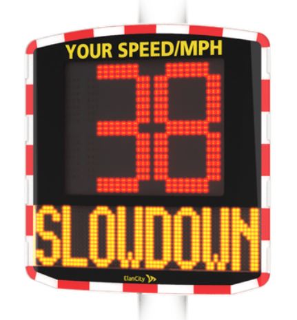
Scarisbrick Parish Council has two speed indicating devices (SpIDs) which are rotated around the eight locations listed below. The figures represent the latest data for each location. The SpIDs collect data from traffic approaching the unit from the front (incoming) and from behind (outgoing).

These figures were obtained with the SpID unit deployed which in itself is likely to affect drivers’ behaviour and reduce speeds. Speeds when the SpID is not deployed may be higher. The figures give an indication of the effect of the SpID during the time period stated and should NOT be considered as representative of any other time. The SpID unit has an “anti-race” facility and stops displaying speeds above a pre-selected level.


SMITHY LANE (Southport Road proximity) – 30mph speed limit

Time period:
July 2022 to November 2022

Number of vehicles:
Incoming (from Southport Rd) – 138,138
Outgoing (towards Southport Rd) – 137,107

Proportion travelling within speed limit:
Incoming – 46%
Outgoing – 44%

Average speed of all vehicles:
Incoming – 32.18 mph
Outgoing – 32.39 mph

Maximum speed recorded by a single vehicle:
Incoming – 131 mph
Outgoing – 111 mph


SMITHY LANE (Heatons Bridge Road proximity) – 30mph speed limit

Time period:
July 2022 to November 2022

Number of vehicles:
Incoming (from Heatons Bridge Rd) – 119,117
Outgoing (towards Heatons Bridge Rd) – 119,472

Proportion travelling within speed limit:
Incoming – 66%
Outgoing – 46%

Average speed of all vehicles:
Incoming – 29.13 mph
Outgoing – 31.52 mph

Maximum speed recorded by a single vehicle:
Incoming – 83 mph
Outgoing – 86 mph


HEATONS BRIDGE ROAD – 40mph speed limit

Time period:
November 2022 to January 2023

Number of vehicles:
Incoming (towards Southport) – 40,495
Outgoing (towards Ormskirk) – 62,845

Proportion travelling within speed limit:
Incoming – 79%
Outgoing – 74%

Average speed of all vehicles:
Incoming – 38.77 mph
Outgoing – 39.43 mph

Maximum speed recorded by a single vehicle:
Incoming – 91 mph
Outgoing – 99 mph


TURNING LANE (Southport Road proximity) – 30mph speed limit

Time period:
November 2022 to January 2023

Number of vehicles:
Incoming (from Southport Rd junction) – 22,126
Outgoing (towards Southport Rd junction) – 24,918

Proportion travelling within speed limit:
Incoming – 95%
Outgoing – 91%

Average speed of all vehicles:
Incoming – 23.01 mph
Outgoing – 24.41 mph

Maximum speed recorded by a single vehicle:
Incoming – 58 mph
Outgoing – 65 mph


TURNING LANE (Jacksmers Lane proximity) – 30mph speed limit

Time period:
TBA

Number of vehicles:
Incoming (from Jacksmere Lane junction) – TBA
Outgoing (towards Jacksmere Lane junction) – TBA

Proportion travelling within speed limit:
Incoming – TBA
Outgoing – TBA

Average speed of all vehicles:
Incoming – TBA
Outgoing – TBA

Maximum speed recorded by a single vehicle:
Incoming – TBA
Outgoing – TBA


POOL HEY LANE (Southport Road proximity) – 30mph speed limit

Time period:
TBA

Number of vehicles:
Incoming (from Southport Rd junction) – TBA
Outgoing (towards Southport Rd junction) – TBA

Proportion travelling within speed limit:
Incoming – TBA
Outgoing – TBA

Average speed of all vehicles:
Incoming – TBA
Outgoing – TBA

Maximum speed recorded by a single vehicle:
Incoming – TBA
Outgoing – TBA


POOL HEY LANE (Wyke Lane proximity) – 30mph speed limit

Time period:
TBA

Number of vehicles:
Incoming (from Wyke Lane direction) – TBA
Outgoing (towards Wyke Lane direction) – TBA

Proportion travelling within speed limit:
Incoming – TBA
Outgoing – TBA

Average speed of all vehicles:
Incoming – TBA
Outgoing – TBA

Maximum speed recorded by a single vehicle:
Incoming – TBA
Outgoing – TBA


BESCAR BROW LANE – 30mph speed limit

Time period:
TBA

Number of vehicles:
Incoming (from Southport Rd junction) – TBA
Outgoing (towards Southport Rd junction) – TBA

Proportion travelling within speed limit:
Incoming – TBA
Outgoing – TBA

Average speed of all vehicles:
Incoming – TBA
Outgoing – TBA

Maximum speed recorded by a single vehicle:
Incoming – TBA
Outgoing – TBA

Scarisbrick website shield

Community Infrastructure Levy 2018-19

The Community Infrastructure Levy is a levy paid by developers to improve the infrastructure within the area of their developments.

Parish Councils receive a percentage of the levy to use within the Parish. Between 2015 and 2019 the Council received £5900.83 to improve the local infrastructure.

During 2019-2020 the Council allocated the levy to improve access to local transport support and to repairs at the Village Hall

The statutory report can be downloaded here:

CIL2018-19Scarisbrick

Ocean image

Flooding – be prepared

Fortunately, the local flooding experienced at Christmas 2015 was not repeated this year. However, we cannot be complacent as we move into the New Year.

Lancashire County Council has produced some useful advice on its website about how people can be more prepared for flooding. Flooding can never be totally prevented but, if you are prepared, the impact to people and property can usually be reduced.  The information can be accessed at www.lancashire.gov.uk/flooding and includes the following contact information:

Lancashire Police – 999If there is an immediate risk to life call the police.

Environment Agency Floodline – 0345 988 1188 – To report a flood or if your property is at risk of flooding from a reservoir, river or coastal water.

United Utilities – 0345 6723 723 – If flooding is from sewers or burst water mains.

Power cuts – 105 – To report a power cut or get updates if your electricity has been cut off. 

Lancashire County Council – 0300 123 6780 – If flooding is from highway drainage, surface water, groundwater or watercourses.


The following video contains some practical advice:


Flood investigation report – December 2015 floods

Lancashire County Council, as Lead Local Flood Authority, has now published district level reports which provide affected communities with information about what the relevant risk management authorities are doing in their areas to help manage the risk of flooding from a variety of sources.

The reports provide information on investigations undertaken at each of the affected locations, flood risk improvements already completed as well as opportunities for further investigation and investment in flood-prevention measures.  They also provide information for concerned homeowners and businesses on what they can do to help protect their own properties from flooding in the future.

The West Lancashire District Flood Report was published in November 2016 and can be found at http://www.lancashire.gov.uk/media/900009/west-lancashire-stage-2-report.pdf

Scarisbrick Parish Council would be interested to hear your views on the report.


Bus-shelter update

Bus-shelter update

Scarisbrick Parish Council is continuing with its rolling programme of bus-shelter replacement. Some of the Council’s current timber shelters are more than 40 years old and maintenance costs are increasing. They are particularly susceptible to rot where the bases make contact with the ground. This often involves the structural framework of the shelters and is difficult to repair.

BS5

Timber shelter (Image care of Rept0n1x at Wikimedia Commons).

Although timber bus-shelters have been a distinctive feature of the Parish for many years the decision was taken to replace with modern aluminium framed shelters. These are more durable and cheaper to maintain than their timber counterparts and are therefore more in keeping with the Council’s responsibility to obtain value for money. Visibility is also much improved as buses can be seen from inside the shelter and bus drivers can see waiting passengers. The shelters should also be more resistant to vandalism.

Budget constraints mean that we are able to replace one (possibly two) shelters per year without unacceptable increases in the precept. This is being done in order of priority based upon information from regular asset inspection. Up to now the shelters at Otterstye, St.Mark’s School, New Hall Drive, and Carr Cross (Ormskirk direction) have been replaced. The latter two shelters have recently benefitted from the addition of front panels to protect from prevailing winds.

The shelter at the lower end of Bescar Brow (almost opposite Woodlands Avenue) has been identified as the next priority. This will be a semi-enclosed bus-shelter to protect from the wind. It will have a tinted polycarbonate roof. The front, side and rear panels will be glazed with toughened safety glass which is hard wearing and vandal resistant. Perch seating is included. An order was placed just before Christmas and there is an expected lead time of two to three weeks for installation.

BS3

Drawing of proposed bus-shelter on Bescar Brow.

The shelters at Heatons Bridge and the Elephant restaurant have been identified as the next priorities for the new financial year. The shelter on Moorfield Lane has been removed following collision by a vehicle. This is currently subject to an insurance claim and should be replaced soon.

BS2

Damage to Moorfield Lane shelter.